

An interview by Sarah Collett of Dr. John Sorenson:– thoughtful faith podcast.

Dr. Sorenson is an emeritus professor of anthropology at Brigham Young University, and a renowned expert of Book of Mormon archeology and geography. His seminal work An Ancient American Setting for the Book of Mormon popularized the Limited Geography Theory within LDS culture and scholarship, and has been the primary reference point for both apologetic and critical approaches to the historicity of the Book of Mormon. Since his retirement from BYU, Dr. Sorenson has dedicated over two decades of research into the body of work that will be released in his upcoming book Mormon’s Codex, which will be published through the Neal A. Maxwell Institute of Religious Scholarship.
005: John Sorenson on Book of Mormon Historicity
The Book of Mormon, published in 1829, describes two advanced, literate ancient American civilizations. According to the Book of Mormon, the Jaredites arrived in around 2500 BC. Jaredite culture endured until 580 BC although its cultural influence persisted for centuries afterward. Another group arrived in 587 BC and soon split into rival factions known as the Lamanites and the Nephites. The Nephites were eventually destroyed by the Lamanites in 385 AD. One of the few cities in Mesoamerica that retained its Preclassic name is called Lamanai—a close cognate to Lamanite and to the name of a Lamanite king: Lamoni.
The Book of Mormon was published long before anyone knew anything about the Olmec or the Maya. (“Olmec” and “Maya” are not the original names of the civilizations they describe. We don’t know what those groups called themselves or how many distinct civilizations may have been grouped under those monikers.) Joseph Smith was harshly criticized for claiming that Native Americans built sophisticated civilizations. Many criticisms of the Book of Mormon have fallen by the wayside as archaeology and linguistics have advanced.
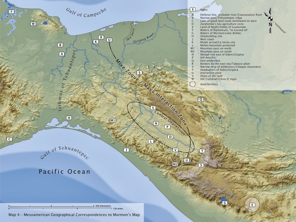
The Book of Mormon contains a detailed textual map that, according to John L. Sorenson, closely matches the terrain and archaeological sites in Mesoamerica from Kaminaljuyu to Tres Zapotes.
The Book of Mormon’s textual map and its description of centuries of conflict between the Nephites and the Lamanites line up with Gareth W. Lowe’s publication entitled “The Mixe-Zoque as competing neighbors of the early lowland Maya.”
The map below is based on Lowe’s work and shows the approximate dividing line between the Mixe-Zoque to the left and the Maya to the right. This line corresponds to Sorenson’s proposed dividing line between the Nephites and the Lamanites at the height of Nephite civilization circa 100 BC.
The Book of Mormon’s description of millions of ancient inhabitants in an area only a few hundred miles long was scoffed at until very recently when LiDAR imaging proved that the area around Tikal alone supported a population in the millions.
This Ancient Civilization Was Twice As Big As Medieval England
The advent of LiDAR revealed just how sophisticated and massive Mesoamerican civilization was. Tens of thousands of unstudied sites are buried under the jungle. Many others have been hiding in plain site. Our understanding of ancient Mesoamerica could be radically altered in the coming years.
