

Tribes of Florida – Brief Descriptions
- Cahuilla, North American Indian tribe that spoke a Uto-Aztecan language. They originally lived in what is now southern California, in an inland basin of desert plains and rugged canyons south of the San Bernardino and San Jacinto mountains. The Cahuilla traditionally lived in thatched or adobe houses or in sun shelters without walls and were skilled in basketry and pottery. Their social organization was patrilineal and apparently divided into halves, or moieties, which guided such matters as descent and marriage. As with other California Indians, traditional Cahuilla subsistence relied upon acorns, mesquite, and a variety of small game. https://www.britannica.com/topic/Cahuilla
- Ais The Ais were noted as the most important tribe of southeastern Florida, and they were probably responsible for the fact that the watercourse on which they dwelt came to be called Indian River.
Hernando de Escalante Fontaneda (c. 1536 – after 1575) wrote of a Biscayan named Pedro who had been held prisoner [by the] Ais, evidently during the sixteenth century, and spoke the Ais language fluently. Shortly after the Spaniards made their first establishments in the peninsula, a war broke out with the Ais, but peace was concluded in 1570. In 1597 Governor Mendez de Canço, who traveled along the entire east coast from the head of the Florida Keys to St. Augustine, reported that the Ais chief had more Indians under him than any other.
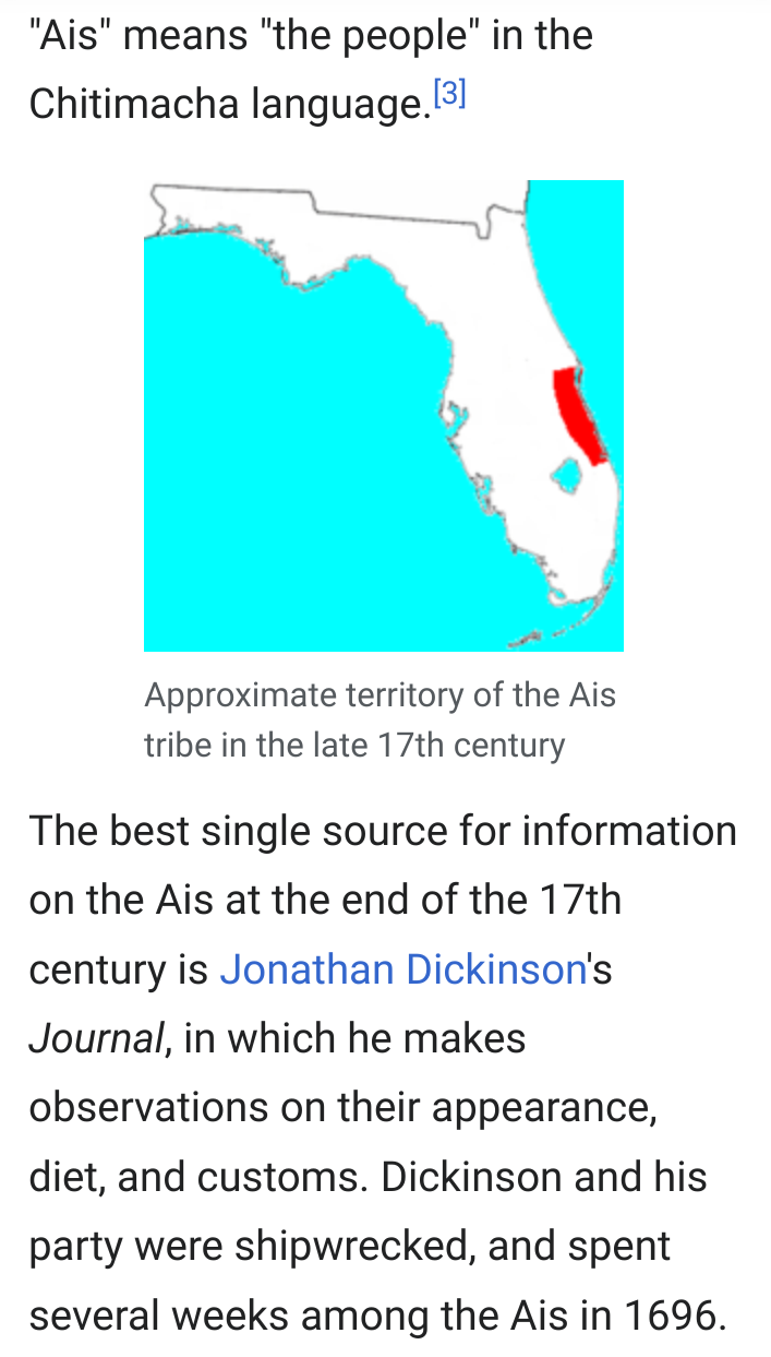
[Excerpts from Access Genealogy: Florida Indian Tribes. See also: “Ais Tribe of Florida” http://www.accessgenealogy.com/native/ais-tribe-of-florida.htm ] - The Ais or Ays were a Native American people of eastern Florida. Their territory included coastal areas and islands from approximately Cape Canaveral to the Indian River.[1] The Ais chiefdom consisted of a number of towns, each led by a chief who was subordinate to the paramount chief of Ais; the Indian River was known as the “River of Ais” to the Spanish.[2] The Ais language has been linked to the Chitimacha language by linguist Julian Granberry, who points out that “Ais” means “the people” in the Chitimacha language.[3]
The best single source for information on the Ais at the end of the 17th century is Jonathan Dickinson‘s Journal, in which he makes observations on their appearance, diet, and customs. Dickinson and his party were shipwrecked, and spent several weeks among the Ais in 1696. By Dickinson’s account, the chief of the town of Jece, near present-day Sebastian,[4] was paramount to all of the coastal towns from the Jaega town of Jobe (at Jupiter Inlet) in the south to approximately Cape Canaveral in the north (that is, the length of the River of Ais).[5]
In December of 1571, Pedro Menéndez de Avilés was sailing from Florida to Havana with two frigates when, as he tells it,
I was wrecked at Cape Canaveral because of a storm which came upon me, and the other boat was lost fifteen leagues further on in the Bahama Channel, in a river they call the Ais, because the cacique is so called. I, by a miracle reached the fort of St. Augustine with seventeen persons I was taking with me. Three times the Indians gave the order to attack me, and the way I escaped them was by ingenuity and arousing fear in them, telling them that behind me many Spaniards were coming who would slay them if they found them.[8]
In 1605, Governor Pedro de Ibarra sent a soldier, Álvaro Mexía, on a diplomatic mission to the Ais nation. The mission was a success; the Ais agreed to care for shipwrecked sailors for a ransom, and Mexía completed a map of the Indian River area with their help.[9] Numerous European artifacts from shipwrecks have been found in Ais settlements. When the Dickinson party reached the town, there was already in Jece another group of English from a shipwreck. European and African survivors of shipwrecks were fairly common along the coast.[citation needed] The Ais also traded with St. Augustine. Dickinson reports that one man of Jece had approximately five pounds of ambergris; he “boasted that when he went for Augustine with that, he would purchase of the Spaniards a looking-glass, an axe, a knife or two, and three or four mannocoes (which is about five or six pounds) of tobacco.”[10]
The Mayaca, who lived along the upper St. Johns River south of Lake George, appear to have spoken a language related to that of the Ais. The Surruque to the north and the Jaega to the south were politically subordinate to the Ais.
https://en.m.wikipedia.org/wiki/Ais_people
It is currently thought that the Ais did not survive long after Dickinson’s sojourn with them. Shortly after 1700, settlers in the Province of Carolina and their Indian allies started raiding the Ais, killing some and carrying captives to Charles Town to be sold as slaves. In 1743, the Spanish established a short-lived mission on Biscayne Bay (in the area of present-day Miami). The priests assigned to that mission reported the presence of people they called “Santa Luces”, perhaps a name for the Ais derived from “Santa Lucia”, somewhere to the north of Biscayne Bay.[11] The Ais disappear from area records after 1760.
The Ais had already had considerable contact with Europeans by this time. The Spanish became acquainted with the Ais in middle of the 16th century. In 1566 Pedro Menéndez de Avilés, founder of St. Augustine, Florida, established a fort and mission at an Ais town, which the Spanish called Santa Lucía.[6] After the Ais attacked the fort, killing 23 of the soldiers, the Spanish abandoned the fort and mission.[7] Spain eventually established some control over the coast; at the time, the Ais considered them friends (comerradoes) and non-Spanish Europeans as enemies. A number of Ais men learned some Spanish, and a patrol of Spanish soldiers from St. Augustine arrived in Jece while the Dickinson party was there. One Ais man in Jece had been taken away by the English to work as a diver on a wreck east of Cuba. He got away when the ship put in for water in Cuba, and made his way back to his home via Havana and St. Augustine.
- Cahuilla, North American Indian tribe that spoke a Uto-Aztecan language. They originally lived in what is now southern California, in an inland basin of desert plains and rugged canyons south of the San Bernardino and San Jacinto mountains. The Cahuilla traditionally lived in thatched or adobe houses or in sun shelters without walls and were skilled in basketry and pottery. Their social organization was patrilineal and apparently divided into halves, or moieties, which guided such matters as descent and marriage. As with other California Indians, traditional Cahuilla subsistence relied upon acorns, mesquite, and a variety of small game;
- The Calusa (/kəˈluːsə/ kə-LOO-sə) were a Native American people of Florida‘s southwest coast. Calusa society developed from that of archaic peoples of the Everglades region. Previous indigenous cultures had lived in the area for thousands of years.
At the time of European contact in the 16th and 17th centuries, the historic Calusa were the people of the Caloosahatchee culture. They are notable for having developed a complex culture based on estuarine fisheries rather than agriculture. Calusa territory reached from Charlotte Harbor to Cape Sable, all of present-day Charlotte, Lee, and Collier counties, and may have included the Florida Keys at times. They had the highest population density of South Florida; estimates of total population at the time of European contact range from 10,000 to several times that, but these are speculative.
Calusa political influence and control also extended over other tribes in southern Florida, including the Mayaimi around Lake Okeechobee, and the Tequesta and Jaega on the southeast coast of the peninsula. Calusa influence may have also extended to the Ais tribe on the central east coast of Florida.[1]
CultureEdit
Early Spanish and French sources referred to the tribe, its chief town, and its chief as Calos, Calus, Caalus, and Carlos. Hernando de Escalante Fontaneda, a Spaniard held captive by the Calusa in the 16th century, recorded that Calusa meant “fierce people” in their language. By the early 19th century, Anglo-Americans in the area used the term Calusa for the people. It is based on the Creek and Mikasuki (languages of the present-day Seminole and Miccosukee nations) ethnonym for the people who had lived around the Caloosahatchee River (also from the Creek language).[2]
Juan Rogel, a Jesuit missionary to the Calusa in the late 1560s, noted the chief’s name as Carlos, but wrote that the name of the kingdom was Escampaba, with an alternate spelling of Escampaha. Rogel also stated that the chief’s name was Caalus, and that the Spanish had changed it to Carlos. Marquardt quotes a statement from the 1570s that “the Bay of Carlos … in the Indian language is called Escampaba, for the cacique of this town, who afterward called himself Carlos in devotion to the Emperor” (Charles V, Holy Roman Emperor). Escampaba may be related to a place named Stapaba, which was identified in the area on an early 16th-century map.[2]
Origins
See also: Indigenous people of the Everglades region
Paleo-Indians entered what is now Florida at least 12,000 years ago. By around 5000 BC, people started living in villages near wetlands. Favored sites were likely occupied for multiple generations. Florida’s climate had reached current conditions and the sea had risen close to its present level by about 3000 BC. People commonly occupied both fresh and saltwater wetlands. Because of their reliance on shellfish, they accumulated large shell middens during this period. Many people lived in large villages with purpose-built earthwork mounds, such as those at Horr’s Island. People began creating fired pottery in Florida by 2000 BC.[3]
By about 500 BC, the Archaic culture, which had been fairly uniform across Florida, began to devolve into more distinct regional cultures.[3] Some Archaic artifacts have been found in the region later occupied by the Calusa, including one site classified as early Archaic, and dated prior to 5000 BC. There is evidence that the people intensively exploited Charlotte Harbor aquatic resources before 3500 BC. Undecorated pottery belonging to the early Glades culture appeared in the region around 500 BC. Pottery distinct from the Glades tradition developed in the region around AD 500, marking the beginning of the Caloosahatchee culture. This lasted until about 1750, and included the historic Calusa people. By 880, a complex society had developed with high population densities. Later periods in the Caloosahatchee culture are defined in the archaeological record by the appearance of pottery from other traditions.
The Caloosahatchee culture inhabited the Florida west coast from Estero Bay to Charlotte Harbor and inland about halfway to Lake Okeechobee, approximately covering what are now Charlotte and Lee counties. At the time of first European contact, the Caloosahatchee culture region formed the core of the Calusa domain. Artifacts related to fishing changed slowly over this period, with no obvious breaks in tradition that might indicate a replacement of the population.[4]
Between 500 and 1000, the undecorated, sand-tempered pottery that had been common in the area was replaced by “Belle Glade Plain” pottery. This was made with clay containing spicules from freshwater sponges (Spongilla), and it first appeared inland in sites around Lake Okeechobee. This change may have resulted from the people’s migration from the interior to the coastal region, or may reflect trade and cultural influences. There was little change in the pottery tradition after this. The Calusa were descended from people who had lived in the area for at least 1,000 years prior to European contact, and possibly for much longer than that.[4]
The Calusa diet at settlements along the coast and estuaries consisted primarily of fish, in particular pinfish (Lagodon rhomboides), pigfish (redmouth grunt), (Orthopristis chrysoptera) and hardhead catfish (Ariopsis felis). These small fish were supplemented by larger bony fish, sharks and rays, mollusks, crustaceans, ducks, sea turtles and land turtles, and land animals. When Pedro Menéndez de Avilés visited in 1566, the Calusa served only fish and oysters to the Spanish. An analysis of faunal remains at one coastal habitation site, the Wightman site (on Sanibel Island), showed that more than 93 percent of the energy from animals in the diet came from fish and shellfish, less than 6 percent of the energy came from mammals, and less than 1 percent came from birds and reptiles. By contrast, at an inland site, Platt Island, mammals (primarily deer) accounted for more than 60 percent of the energy from animal meat, while fish provided just under 20 percent.[8]
Some authors have argued that the Calusa cultivated maize and Zamia integrifolia (coontie) for food. But Widmer argues that the evidence for maize cultivation by the Calusa depends on the proposition that the Narváez and de Soto expeditions landed in Charlotte Harbor rather than Tampa Bay, which is now generally discounted. No Zamia pollen has been found at any site associated with the Calusas, nor does Zamia grow in the wetlands that made up most of the Calusa environment. Marquardt notes that the Calusa turned down the offer of agricultural tools from the Spanish, saying that they had no need for them. The Calusa gathered a variety of wild berries, fruits, nuts, roots and other plant parts. Widmer cites George Murdock‘s estimate that only some 20 percent of the Calusa diet consisted of wild plants that they gathered. However, no evidence of plant food was found at the Wightman site. There is evidence that as early as 2,000 years ago, the Calusa cultivated papaya (Catrica papaya), a gourd of the species Cucurbita pepo, and the bottle gourd, the last two of which were used for net floats and dippers.[8]
https://en.m.wikipedia.org/wiki/Calusa
Treaty of Tordesillas
Columbus’s colonization of the Atlantic islands inaugurated an era of aggressive Spanish expansion across the Atlantic. Spanish colonization after Columbus accelerated the rivalry between Spain and Portugal to an unprecedented level. The two powers vied for domination through the acquisition of new lands. In the 1480s, Pope Sixtus IV had granted Portugal the right to all land south of the Cape Verde islands, leading the Portuguese king to claim that the lands discovered by Columbus belonged to Portugal, not Spain. But in 1493, Spanish-born Pope Alexander VI issued two papal decrees giving legitimacy to Spain’s Atlantic claims over the claims of Portugal. Hoping to salvage Portugal’s holdings, King João II negotiated a treaty with Spain. The Treaty of Tordesillas in 1494 drew a north-to-south line through South America. Spain gained territory west of the line, while Portugal retained the lands east of the line, including the east coast of Brazil.
Following his defeat, Cortés slowly created alliances and recruited tens of thousands of native peoples who resented Aztec rule. Only by playing upon the disunity among the diverse groups in the Aztec Empire were the Spanish able to capture Tenochtitlán. In August 1521, Cortés claimed Tenochtitlán for Spain and renamed it Mexico City. The Spanish also brought smallpox, which took a heavy toll on the people in Tenochtitlán. Illness played a much greater role in the city’s downfall than violence. Cortés was also aided by a Nahua woman called Malintzin—also known as La Malinche or Doña Marina, her Spanish name—whom the natives of Tabasco gave him as tribute. Malintzin translated for Cortés and, whether willingly or under duress, entered into a physical relationship with him. Their son, Martín, may have been the first mestizo—person of mixed indigenous American and European descent. Malintzin remains a controversial figure in the history of the Atlantic World; some people view her as a traitor because she helped Cortés conquer the Aztecs, while others see her as a victim of European expansion. Regardless, without Malintzin’s help, Cortés would not have been able to dismantle the Aztec Empire.
.- Apalachee From at least A.D. 1000, a group of farming Indians was living in northwest Florida. They were called the Apalachees. Other Florida Indians regarded them as being wealthy and fierce. Some think the Apalachee language was related to Hitchiti of the Muskhogean language family. The Apalachees’ territory extended from the Aucilla River in the east to the Ochlockonee River in the west.
[Excerpt from: Florida Center for Instructional Technology: The Apalachees of Northwest Florida.]
. - Calusa The Calusa Indians were originally called the “Calos” which means “Fierce People.” They were descendants of Paleo-Indians who inhabited Southwest Florida approximately 12,000 years ago. During the Calusa’s reign the Florida coastline extended roughly 60 miles further into the Gulf of Mexico. Hardwood forests covered the land and the climate was much colder than it is today. The Calusa inhabited a region abundant with bears, woolly mammoths, sloth, tortoises, and saber-toothed tigers. Hunting these animals and gathering roots and fruit that grew on trees was a mainstay until they discovered the waters contained a wealth of fish. This new food source required significantly less time than hunting and gathering their food, and allowed the Calusa time to establish their own system of government. Following this formation of a centralized government were the construction of a canal system, the beginnings of organized religion, and the creating of many art forms.
[Excerpt from: Absolutely Florida Websource: The Calusa Indians (The Shell People.)]
. - Jeaga The Jeaga (YAY•gah) inhabited present day Palm Beach County. Jonathan Dickson, who survived a shipwreck on the coast near Jeaga lands in 1698, described them as “fierce and bloody.” The Jeaga depended on the sea for much of their food.
[Excerpt from: Florida Online, Social Studies, Glenco Online: People of Southeastern Florida. http://glencoe.com/sec/socialstudies/fcat/early_florida.html#peopleofsoutheasternflorida Read Jonathan Dickson’s journal at http://www.archive.org/stream/godsprotectingpr00dick#page/n5/mode/2up ]
. - Mayaimi Along the lower Atlantic Coast was the home of many small tribes: the Tequestas of Biscayne Bay, the Ais and the Jeagas up the coast, the Keys Indians, and the Mayaimi who built large mounded villages near Lake Okeechobee. Like the Calusa, these tribes were fishermen and hunters rather than farmers.
[Excerpt from: FloridaHistory.org: Florida of the Indians.]
. - Potano The Potano tribe was anciently celebrated as, with one or two possible exceptions, the most powerful of all the Timucua peoples. Located in the territory of the present Alachua County.
[Excerpts from: Access Genealogy: Florida Indian Tribes.]
. - Seminoles Seminole history begins with bands of Creek Indians from Georgia and Alabama who migrated to Florida in the 1700s. Conflicts with Europeans and other tribes caused them to seek new lands to live in peace. Groups of Lower Creeks moved to Florida to get away from the dominance of Upper Creeks. Some Creeks were searching for rich, new fields to plant corn, beans, and other crops. For a while, Spain even encouraged these migrations to help provide a buffer between Florida and the British colonies. The 1770s is when Florida Indians collectively became known as Seminole, a name meaning “wild people” or “runaway.”
[Excerpt from: Florida Department of State’s Division of Resources’ Seminole History Report.]
. - Tequesta The Tequesta were a small, peaceful, Native American tribe. They were one of the first tribes in South Florida and they settled near Biscayne Bay in the present-day Miami area. They built many villages at the mouth of the Miami River and along the coastal islands. Like the other tribes in South Florida, the Tequesta were hunters and gatherers.
[Excerpt from Exploring Florida: The Tequesta of Biscayne Bay, Produced by the Florida Center for Instructional Technology, College of Education, University of South Florida.]
. - Timucua The Timucua lived in large circular houses with palm-thatched roofs. Frequently, they built a wall of tall wooden poles around their villages for protection against attack. Like most Native Americans, the Timucua had no written language. They farmed the rich lands of North Florida.
[Excerpt from: Florida Online, Social Studies, Glenco Online: The Timucua and the Apalachee: http://glencoe.com/sec/socialstudies/fcat/early_florida.html#timucuaandtheapalachee ]
. - Tocobaga The Tocobaga Indians were a group of prehistoric and historic Native Americans living near Tampa Bay, Florida up until roughly 1760. All of the Tampa Bay inhabitants relied heavily on water animals and plants for food, but also hunted and gathered on land. Of all these groups, only the Tocobaga planted corn.
[Excerpt from: Pelotes Island Nature Reserve: Who Were the Tocobago Indians? See more: https://web.archive.org/web/20150201034007/http://pelotes.jea.com/Tocob.htm ]

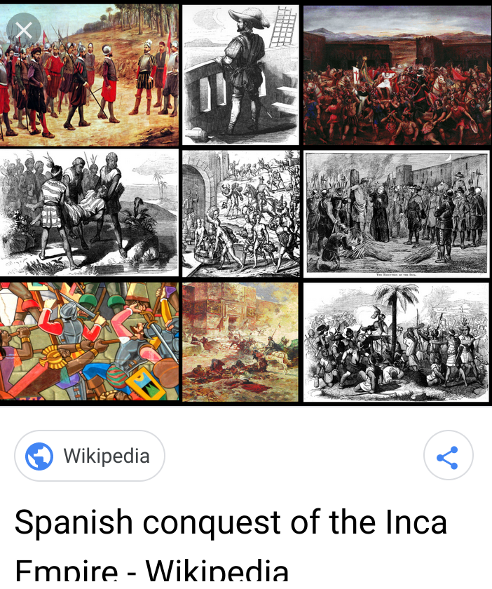
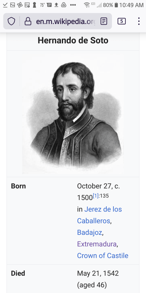
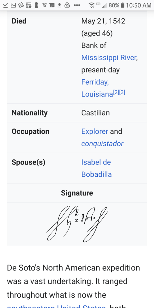


Hernando de Soto (/də ˈsoʊtoʊ/;[4] Spanish: [eɾˈnando ðe ˈsoto]; c. 1500 – May 21, 1542) was a Spanish explorer and conquistador who was involved in expeditions in Nicaragua and the Yucatan Peninsula. He played an important role in Francisco Pizarro‘s conquest of the Inca Empire in Peru, but is best known for leading the first European expedition deep into the territory of the modern-day United States (through Florida, Georgia, Alabama, Mississippi, and most likely Arkansas). He is the first European documented as having crossed the Mississippi River.[5]
De Soto’s North American expedition was a vast undertaking. It ranged throughout what is now the southeastern United States, both searching for gold, which had been reported by various Native American tribes and earlier coastal explorers, and for a passage to China or the Pacific coast. De Soto died in 1542 on the banks of the Mississippi River;[6] different sources disagree on the exact location, whether it was what is now Lake Village, Arkansas, or Ferriday, Louisiana.
Early lifeEdit
Hernando de Soto was born circa 1500 in Extremadura, Spain, to parents who were both hidalgos, nobility of modest means. The region was poor and many people struggled to survive; young people looked for ways to seek their fortune elsewhere. He was born in the current province of Badajoz.[1]:135 Three towns—Badajoz, Barcarrota and Jerez de los Caballeros—claim to be his birthplace. He spent time as a child at each place. He stipulated in his will that his body be interred at Jerez de los Caballeros, where other members of his family were buried.[7] A few years before his birth, the Kingdoms of Castille and Aragon conquered the last Islamic kingdom of the Iberian peninsula. Spain and Portugal were filled with young men seeking a chance for military fame after the defeat of the Moors. With Christopher Columbus‘s discovery of new lands (which he thought to be East Asia) across the ocean to the west, young men were attracted to rumors of adventure, glory and wealth.
In the New WorldEdit
De Soto sailed to the New World with Pedro Arias Dávila, appointed as the first Governor of Panama. In 1520 he participated in Gaspar de Espinosa‘s expedition to Veragua, and in 1524, he participated in the conquest of Nicaragua under Francisco Hernández de Córdoba. There he acquired an encomienda and a public office in León, Nicaragua.[1]:135 Brave leadership, unwavering loyalty, and ruthless schemes for the extortion of native villages for their captured chiefs became de Soto’s hallmarks during the conquest of Central America. He gained fame as an excellent horseman, fighter, and tactician. During that time, de Soto was influenced by the achievements of Iberian explorers: Juan Ponce de León, the first European to reach Florida; Vasco Núñez de Balboa, the first European to reach the Pacific Ocean coast of the Americas (he called it the “South Sea” on the south coast of Panama); and Ferdinand Magellan, who first sailed that ocean to East Asia. In 1530, de Soto became a regidor of León, Nicaragua. He led an expedition up the coast of the Yucatán Peninsula searching for a passage between the Atlantic Ocean and the Pacific Ocean to enable trade with the Orient, the richest market in the world. Failing that, and without means to explore further, de Soto, upon Pedro Arias Dávila‘s death, left his estates in Nicaragua. Bringing his own men on ships which he hired, de Soto joined Francisco Pizarro at his first base of Tumbes shortly before departure for the interior of present-day Peru.[8]:143
Pizarro quickly made de Soto one of his captains.[1]:171
Conquest of PeruEdit
When Pizarro and his men first encountered the army of Inca Atahualpa at Cajamarca, Pizarro sent de Soto with fifteen men to invite Atahualpa to a meeting. When Pizarro’s men attacked Atahualpa and his guard the next day (the Battle of Cajamarca), de Soto led one of the three groups of mounted soldiers. The Spanish captured Atahualpa. De Soto was sent to the camp of the Inca army, where he and his men plundered Atahualpa’s tents.[9]
During 1533, the Spanish held Atahualpa captive in Cajamarca for months while his subjects paid for his ransom by filling a room with gold and silver objects. During this captivity, de Soto became friendly with Atahualpa and taught him to play chess. By the time the ransom had been completed, the Spanish became alarmed by rumors of an Inca army advancing on Cajamarca. Pizarro sent de Soto with 200 soldiers to scout for the rumored army.[10]
While de Soto was gone, the Spanish in Cajamarca decided to kill Atahualpa to prevent his rescue. De Soto returned to report that he found no signs of an army in the area. After executing Atahualpa, Pizarro and his men headed to Cuzco, the capital of the Incan Empire. As the Spanish force approached Cuzco, Pizarro sent his brother Hernando and de Soto ahead with 40 men. The advance guard fought a pitched battle with Inca troops in front of the city, but the battle had ended before Pizarro arrived with the rest of the Spanish party. The Inca army withdrew during the night. The Spanish plundered Cuzco, where they found much gold and silver. As a mounted soldier, de Soto received a share of the plunder, which made him very wealthy. It represented riches from Atahualpa’s camp, his ransom, and the plunder from Cuzco.[11]
On the road to Cuzco, Manco Inca Yupanqui, a brother of Atahualpa, had joined Pizarro. Manco had been hiding from Atahualpa in fear of his life, and was happy to gain Pizarro’s protection. Pizarro arranged for Manco to be installed as the Inca leader. De Soto joined Manco in a campaign to eliminate the Inca armies under Quizquiz, who had been loyal to Atahualpa.[12]:66–67,70–73
By 1534, de Soto was serving as lieutenant governor of Cuzco while Pizarro was building his new capital on the coast; it later became known as Lima. In 1535 King Charles awarded Diego de Almagro, Francisco Pizarro’s partner, the governorship of the southern portion of the Inca Empire. When de Almagro made plans to explore and conquer the southern part of the Inca empire (now Chile), de Soto applied to be his second-in-command, but de Almagro turned him down. De Soto packed up his treasure and returned to Spain.[1]:367,370–372,375,380–381,396

Return to SpainEdit
De Soto returned to Spain in 1536,[1]:135 with wealth gathered from plunder in the Spanish conquest of the Inca Empire. He was admitted into the prestigious Order of Santiago and “granted the right to conquer Florida”.[1]:135 His share was awarded to him by the King of Spain, and he received 724 marks of gold, and 17,740 pesos.[13] He married Isabel de Bobadilla, daughter of Pedrarias Dávila and a relative of a confidante of Queen Isabella.
De Soto petitioned King Charles to lead the government of Guatemala, with “permission to create discovery in the South Sea.” He was granted the governorship of Cuba instead. De Soto was expected to colonize the North American continent for Spain within 4 years, for which his family would be given a sizable piece of land.
Fascinated by the stories of Cabeza de Vaca, who had survived years in North America after becoming a castaway and had just returned to Spain, de Soto selected 620 Spanish and Portuguese volunteers, including some of mixed-race African descent known as Atlantic Creoles, to accompany him to govern Cuba and colonize North America. Averaging 24 years of age, the men embarked from Havana on seven of the King’s ships and two caravels of de Soto’s. With tons of heavy armor and equipment, they also carried more than 500 head of livestock, including 237 horses and 200 pigs, for their planned four-year continental expedition.
De Soto wrote a new will before embarking on his travels. On 10 May 1539, he wrote in his will:
That a chapel be erected within the Church of San Miguel in Jerez de Los Caballeros, Spain, where De Soto grew up, at a cost of 2,000 ducats, with an altarpiece featuring the Virgin Mary, Our Lady of the Conception, that his tomb be covered in a fine black broadcloth topped by a red cross of the Order of the Knights of Santiago, and on special occasions a pall of black velvet with the De Soto coat of arms be placed on the altar; that a chaplain be hired at the salary of 12,000 maravedis to perform five masses every week for the souls of De Soto, his parents, and wife; that thirty masses be said for him the day his body was interred, and twenty for our Lady of the Conception, ten for the Holy Ghost, sixty for souls in purgatory and masses for many others as well; that 150000 maravedis be given annually to his wife Isabel for her needs and an equal amount used yearly to marry off three orphan damsels…the poorest that can be found,” to assist his wife and also serve to burnish the memory of De Soto as a man of charity and substance.[14]
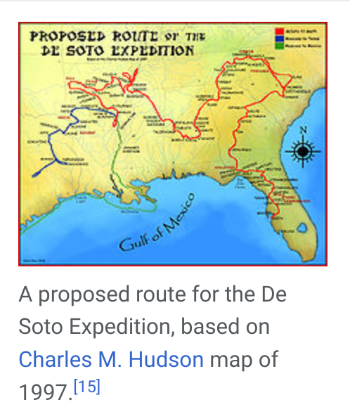
In May 1539, de Soto landed nine ships with over 620 men[30] and 220 horses in an area generally identified as south Tampa Bay. Historian Robert S. Weddle has suggested that he landed at either Charlotte Harbor or San Carlos Bay.[31] He named the land as Espíritu Santo after the Holy Spirit. The ships carried priests, craftsmen, engineers, farmers, and merchants; some with their families, some from Cuba, most from Europe and Africa. Few of the men had traveled before outside of Spain, or even away from their home villages.
Near de Soto’s port, the party found Juan Ortiz, a Spaniard living with the Mocoso people. Ortiz had been captured by the Uzita while searching for the lost Narváez expedition; he later escaped to Mocoso. Ortiz had learned the Timucua language and served as an interpreter to de Soto as he traversed the Timucuan-speaking areas on his way to Apalachee.[32]
Ortiz developed a method for guiding the expedition and communicating with the various tribes, who spoke many dialects and languages. He recruited guides from each tribe along the route. A chain of communication was established whereby a guide who had lived in close proximity to another tribal area was able to pass his information and language on to a guide from a neighboring area. Because Ortiz refused to dress as an hidalgo Spaniard, other officers questioned his motives. De Soto remained loyal to Ortiz, allowing him the freedom to dress and live among his native friends. Another important guide was the seventeen-year-old boy Perico, or Pedro, from what is now Georgia. He spoke several of the local tribes’ languages and could communicate with Ortiz. Perico was taken as a guide in 1540. The Spanish had also captured other Indians, whom they used as slave labor.[clarification needed] Perico was treated better due to his value to the Spaniards.
The expedition traveled north, exploring Florida’s West Coast, and encountering native ambushes and conflicts along the way. De Soto’s first winter encampment was at Anhaica, the capital of the Apalachee people. It is one of the few places on the route where archaeologists have found physical traces of the expedition. The chroniclers described this settlement as being near the “Bay of Horses”. The bay was named for events of the 1527 Narváez expedition, the members of which, dying of starvation, killed and ate their horses while building boats for escape by the Gulf of Mexico.
1540: The SoutheastEdit
From their winter location in the western panhandle of Florida, having heard of gold being mined “toward the sun’s rising”, the expedition turned northeast through what is now the modern state of Georgia.[33][34] Based on archaeological finds made in 2009 at a remote, privately owned site near the Ocmulgee River, researchers believe that de Soto’s expedition stopped in Telfair County. Artifacts found here include nine glass trade beads, some of which bear a chevron pattern made in Venice for a limited period of time and believed to be indicative of the de Soto expedition. Six metal objects were also found, including a silver pendant and some iron tools. The rarest items were found within what researchers believe was a large council house of the indigenous people whom de Soto was visiting.[35][36]
The expedition continued to present-day South Carolina. There the expedition recorded being received by a female chief (Cofitachequi), who gave her tribe’s pearls, food and other goods to the Spanish soldiers. The expedition found no gold, however, other than pieces from an earlier coastal expedition (presumably that of Lucas Vázquez de Ayllón.)
De Soto headed north into the Appalachian Mountains of present-day western North Carolina, where he spent a month resting the horses while his men searched for gold. De Soto next entered eastern Tennessee. At this point, De Soto either continued along the Tennessee River to enter Alabama from the north (according to John R. Swanton), or turned south and entered northern Georgia (according to Charles M. Hudson). The route that Swanton proposed in 1939 is still generally accepted by most archaeologists and by the U.S. government as the route of the de Soto expedition.[citation needed].
De Soto’s expedition spent another month in the Coosa chiefdom, believed to have been connected to the large and complex Mississippian culture, which extended throughout the Mississippi Valley and its tributaries. He turned south toward the Gulf of Mexico to meet two ships bearing fresh supplies from Havana. Along the way, de Soto was led into Mauvila (or Mabila), a fortified city in southern Alabama.[37] The Mobilian tribe, under chief Tuskaloosa, ambushed de Soto’s army.[37] Other sources suggest de Soto’s men were attacked after attempting to force their way into a cabin occupied by Tuskaloosa.[38] The Spaniards fought their way out, and retaliated by burning the town to the ground. During the nine-hour encounter, about 200 Spaniards died, and 150 more were badly wounded, according to the chronicler Elvas.[39] Twenty more died during the next few weeks. They killed an estimated 2,000-6,000 warriors at Mabila, making the battle one of the bloodiest in recorded North American history.[40]
The Spaniards won a Pyrrhic victory, as they had lost most of their possessions and nearly one-quarter of their horses. The Spaniards were wounded and sickened, surrounded by enemies and without equipment in an unknown territory.[38] Fearing that word of this would reach Spain if his men reached the ships at Mobile Bay, de Soto led them away from the Gulf Coast. He moved into inland Mississippi, most likely near present-day Tupelo, where they spent the winter.
De Soto died of a fever on May 21, 1542, in the native village of Guachoya (historical sources disagree as to whether de Soto died near present-day McArthur, Arkansas, or in Louisiana)[47] on the western bank of the Mississippi.[48] Louisiana erected a historical marker at the estimated site.
Before his death, de Soto chose Luis de Moscoso Alvarado, his former maestro de campo (or field commander), to assume command of the expedition.[49] At the time of death, de Soto owned four Indian slaves, three horses, and 700 hogs.[50]
De Soto had encouraged the local natives to believe that he was a deity, specifically an “immortal Son of the Sun,”[51] as a ploy to gain their submission without conflict. Some of the natives had already become skeptical of de Soto’s deity claims, so his men were anxious to conceal his death. The actual site of his burial is not known. According to one source, de Soto’s men hid his corpse in blankets weighted with sand and sank it in the middle of the Mississippi River during the night.[47]
Return of the expedition to Mexico CityEdit
Main article: Quigualtam
De Soto’s expedition had explored La Florida for three years without finding the expected treasures or a hospitable site for colonization. They had lost nearly half their men, and most of the horses. By this time, the soldiers were wearing animal skins for clothing. Many were injured and in poor health. The leaders came to a consensus (although not total) to end the expedition and try to find a way home, either down the Mississippi River, or overland across Texas to the Spanish colony of Mexico City.
They decided that building boats would be too difficult and time-consuming, and that navigating the Gulf of Mexico was too risky, so they headed overland to the southwest. Eventually they reached a region in present-day Texas that was dry. The native populations were made up mostly of subsistence hunter-gatherers. The soldiers found no villages to raid for food, and the army was still too large to live off the land. They were forced to backtrack to the more developed agricultural regions along the Mississippi, where they began building seven bergantines, or pinnaces.[49] They melted down all the iron, including horse tackle and slave shackles, to make nails for the boats. They survived through the winter, and the spring floods delayed them another two months. By July they set off on their makeshift boats down the Mississippi for the coast.
Taking about two weeks to make the journey, the expedition encountered hostile fleets of war canoes along the whole course. The first was led by the powerful paramount chief Quigualtam, whose fleet followed the boats, shooting arrows at the soldiers for days on end as they drifted through their territory. The Spanish had no effective offensive weapons on the water, as their crossbows had long ceased working. They relied on armor and sleeping mats to block the arrows. About 11 Spaniards were killed along this stretch and many more wounded.
On reaching the mouth of the Mississippi, they stayed close to the Gulf shore heading south and west. After about 50 days, they made it to the Pánuco River and the Spanish frontier town of Pánuco. There they rested for about a month. During this time many of the Spaniards, having safely returned and reflecting on their accomplishments, decided they had left La Florida too soon. There were some fights within the company, leading to some deaths. But, after they reached Mexico City and Viceroy Don Antonio de Mendoza offered to lead another expedition to La Florida, few of the survivors volunteered. Of the recorded 700 participants at the start, between 300 and 350 survived (311 is a commonly accepted figure). Most of the men stayed in the New World, settling in Mexico, Peru, Cuba, and other Spanish colonies.
In the spring of 1541, de Soto demanded 200 men as porters from the Chickasaw.[41] They refused his demand and attacked the Spanish camp during the night. The Spaniards lost about 40 men and the remainder of their limited equipment. According to participating chroniclers, the expedition could have been destroyed at this point, but the Chickasaw let them go.[citation needed]
On May 8, 1541, de Soto’s troops reached the Mississippi River.[5]
De Soto had little interest in the river, which in his view was an obstacle to his mission. There has been considerable research into the exact location where de Soto crossed the Mississippi River. A commission appointed by Franklin D. Roosevelt in 1935 determined that Sunflower Landing, Mississippi, was the “most likely” crossing place. De Soto and his men spent a month building flatboats, and crossed the river at night to avoid the Native Americans who were patrolling the river. De Soto had hostile relations with the native people in this area.[42][43]
In the late 20th century, research suggests other locations may have been the site of de Soto’s crossing, including three locations in Mississippi: Commerce, Friars Point, and Walls, as well as Memphis, Tennessee.[44] Once across the river, the expedition continued traveling westward through modern-day Arkansas, Oklahoma, and Texas. They wintered in Autiamique, on the Arkansas River.[citation needed]
After a harsh winter, the Spanish expedition decamped and moved on more erratically. Their interpreter Juan Ortiz had died, making it more difficult for them to get directions and food sources, and generally to communicate with the Natives. The expedition went as far inland as the Caddo River, where they clashed with a Native American tribe called the Tula in October 1541.[45] The Spaniards characterized them as the most skilled and dangerous warriors they had encountered.[46] This may have happened in the area of present-day Caddo Gap, Arkansas (a monument to the de Soto expedition was erected in that community). Eventually, the Spaniards returned to the Mississippi River.
The Spanish believed that de Soto’s excursion to Florida was a failure. They acquired neither gold nor prosperity and founded no colonies. But the expedition had several major consequences.
It contributed to the process of the Columbian Exchange. For instance, some of the swine brought by de Soto escaped and became the ancestors of feral razorback pigs in the southeastern United States.[52][53][54][55][56]
De Soto was instrumental in contributing to the development of a hostile relationship between many Native American tribes and Europeans. When his expedition encountered hostile natives in the new lands, more often than not it was his men who instigated the clashes.[57]
More devastating than the battles were the chronic diseases carried by the members of the expedition. Because the indigenous people lacked the immunity which the Europeans had acquired through generations of exposure to these Eurasian diseases, the Native Americans suffered epidemics of illness after exposure to such diseases as measles, smallpox, and chicken pox. Several areas traversed by the expedition became depopulated by disease caused by contact with the Europeans. Seeing the high fatalities and devastation caused, many natives fled the populated areas for the surrounding hills and swamps. In some areas, the social structure changed because of high population losses due to epidemics.[58]
The records of the expedition contributed greatly to European knowledge about the geography, biology, and ethnology of the New World. The de Soto expedition’s descriptions of North American natives are the earliest-known source of information about the societies in the Southeast. They are the only European description of the culture and habits of North American native tribes before these peoples encountered other Europeans. De Soto’s men were both the first and nearly the last Europeans to witness the villages and civilization of the Mississippian culture.
De Soto’s expedition led the Spanish crown to reconsider Spain’s attitude toward the colonies north of Mexico. He claimed large parts of North America for Spain. The Spanish concentrated their missions in the state of Florida and along the Pacific coast.
